Saint Vincent and the Grenadines Volcanoes
-
Soufriere St. Vincent
-
Soufriere St. Vincent
-

Soufriere St. Vincent
-
Soufriere St. Vincent
-
Soufriere St. Vincent
-
Soufriere St. Vincent
-
Soufriere St. Vincent
-
Soufriere St. Vincent
-

Soufriere St. Vincent
-
Soufriere St. Vincent
-
Soufriere St. Vincent
-
Soufriere St. Vincent
-
Soufriere St. Vincent
-
Soufriere St. Vincent
-
Soufriere St. Vincent
-
Soufriere St. Vincent
-
Soufriere St. Vincent
-
Soufriere St. Vincent
-
Soufriere St. Vincent
-
Soufriere St. Vincent
Saint Vincent and the Grenadines has 1 Holocene volcanoes. Note that as a scientific organization we provide these listings for informational purposes only, with no international legal or policy implications. Volcanoes will be included on this list if they are within the boundaries of a country, on a shared boundary or area, in a remote territory, or within a maritime Exclusive Economic Zone. Bolded volcanoes have erupted within the past 20 years. Suggestions and data updates are always welcome ().
| Volcano Name | Location | Last Eruption | Primary Volcano Type |
|---|---|---|---|
| Soufriere St. Vincent | St. Vincent | 2021 CE | Stratovolcano |
Chronological listing of known Holocene eruptions (confirmed or uncertain) from volcanoes in Saint Vincent and the Grenadines. Bolded eruptions indicate continuing activity.
| Volcano Name | Start Date | Stop Date | Certainty | VEI | Evidence |
|---|---|---|---|---|---|
| Soufriere St. Vincent | 2020 Dec 27 | 2021 Apr 22 | Confirmed | 4 | Observations: Reported |
| Soufriere St. Vincent | 1979 Apr 13 | 1979 Oct 26 ± 5 days | Confirmed | 3 | Observations: Reported |
| Soufriere St. Vincent | 1971 Oct 4 ± 6 days | 1972 Mar 20 | Confirmed | 0 | Observations: Reported |
| Soufriere St. Vincent | 1902 May 6 | 1903 Mar 30 | Confirmed | 4 | Observations: Reported |
| Soufriere St. Vincent | [1880] | [Unknown] | Uncertain | ||
| Soufriere St. Vincent | 1814 Jan 9 | 1814 Jan 9 | Confirmed | 1 | Observations: Reported |
| Soufriere St. Vincent | 1812 Apr 27 | 1812 Jun 9 (?) | Confirmed | 4 | Observations: Reported |
| Soufriere St. Vincent | 1784 Mar (in or before) | Unknown | Confirmed | 0 | Observations: Reported |
| Soufriere St. Vincent | 1718 Mar 26 (?) | 1718 Mar 29 | Confirmed | 3 | Observations: Reported |
| Soufriere St. Vincent | 1640 ± 50 years | Unknown | Confirmed | Isotopic: 14C (uncalibrated) | |
| Soufriere St. Vincent | 1550 ± 50 years | Unknown | Confirmed | Isotopic: 14C (uncalibrated) | |
| Soufriere St. Vincent | 1480 ± 150 years | Unknown | Confirmed | Isotopic: 14C (uncalibrated) | |
| Soufriere St. Vincent | 1395 ± 75 years | Unknown | Confirmed | Isotopic: 14C (uncalibrated) | |
| Soufriere St. Vincent | 1325 ± 75 years | Unknown | Confirmed | Isotopic: 14C (uncalibrated) | |
| Soufriere St. Vincent | 0905 ± 75 years | Unknown | Confirmed | Isotopic: 14C (uncalibrated) | |
| Soufriere St. Vincent | 0530 BCE ± 75 years | Unknown | Confirmed | Isotopic: 14C (uncalibrated) | |
| Soufriere St. Vincent | 0750 BCE ± 100 years | Unknown | Confirmed | Isotopic: 14C (uncalibrated) | |
| Soufriere St. Vincent | 1600 BCE ± 75 years | Unknown | Confirmed | Isotopic: 14C (uncalibrated) | |
| Soufriere St. Vincent | 2020 BCE ± 75 years | Unknown | Confirmed | Isotopic: 14C (uncalibrated) | |
| Soufriere St. Vincent | 2135 BCE ± 50 years | Unknown | Confirmed | Isotopic: 14C (uncalibrated) | |
| Soufriere St. Vincent | 2200 BCE ± 150 years | Unknown | Confirmed | Isotopic: 14C (uncalibrated) | |
| Soufriere St. Vincent | 2310 BCE ± 100 years | Unknown | Confirmed | Isotopic: 14C (uncalibrated) | |
| Soufriere St. Vincent | 2380 BCE ± 100 years | Unknown | Confirmed | Isotopic: 14C (uncalibrated) |
Saint Vincent and the Grenadines has 2 Pleistocene volcanoes. Note that as a scientific organization we provide these listings for informational purposes only, with no international legal or policy implications. Volcanoes will be included on this list if they are within the boundaries of a country, on a shared boundary or area, in a remote territory, or within a maritime Exclusive Economic Zone. Suggestions and data updates are always welcome ().
| Volcano Name | Location | Primary Volcano Type |
|---|---|---|
| Morne Garu | St. Vincent | Stratovolcano |
| Grand Bonhomme | St. Vincent | Stratovolcano |
There are 21 photos available for volcanoes in Saint Vincent and the Grenadines.
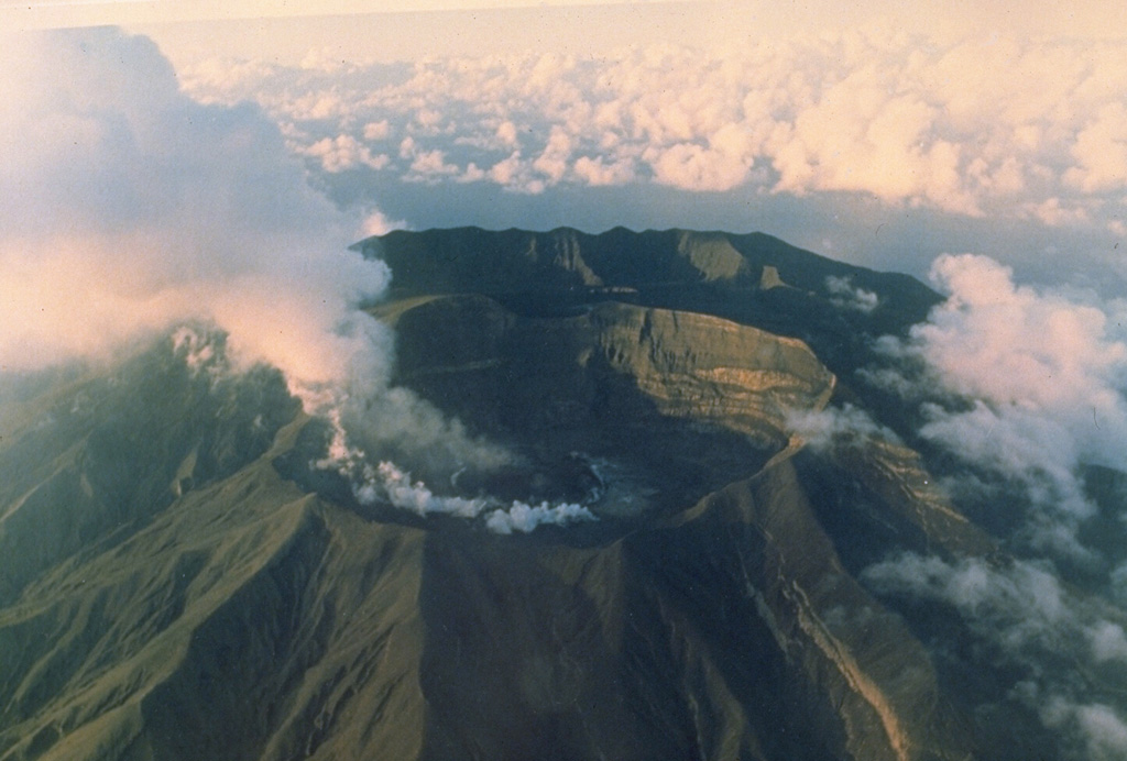
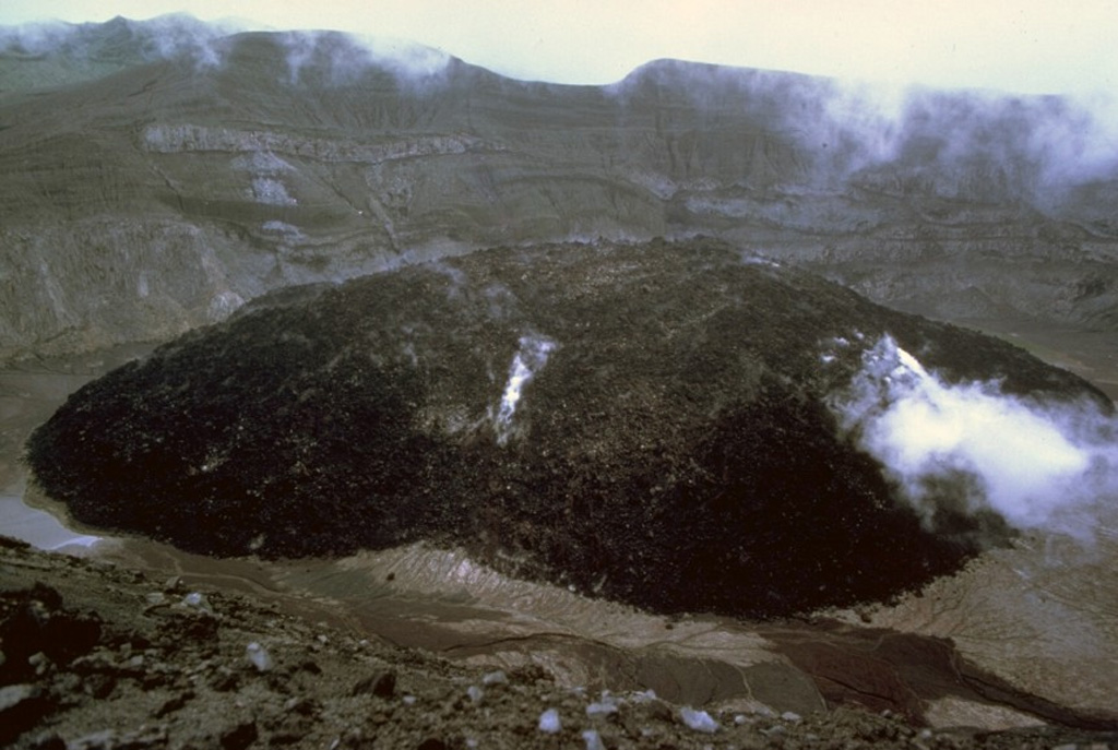
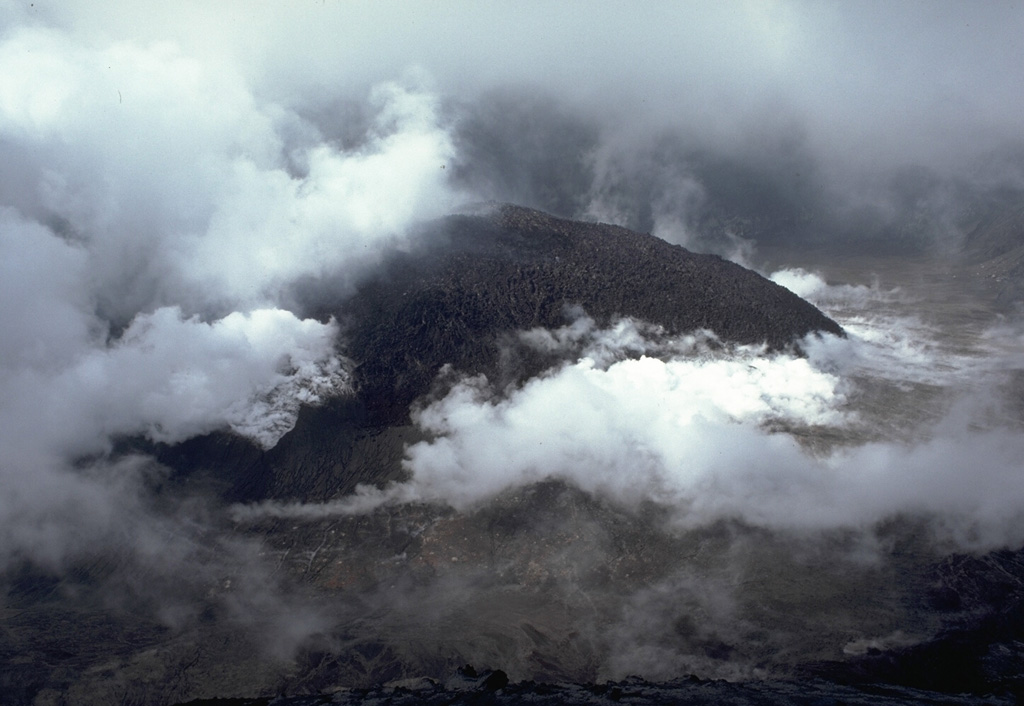
 A lava dome 130 m high and more than 840 m wide filled much of the crater floor of Soufrière St. Vincent volcano during the 1979 eruption. Dome growth began in May, after a series of powerful explosive eruptions 13-15 April, and continued until October. Steam continued to rise from the dome in this 1983 photo from the SW crater rim.
Photo by Richard Fiske, 1983 (Smithsonian Institution).
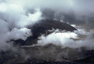 A steaming lava dome fills the floor of the summit crater of Soufrière volcano in June 1979. Both steam clouds from the degassing lava dome and atmospheric clouds are present in this photo. The dome began growing on May 3, after the cessation of explosive eruptions on April 25, and reached a height of 110 m by June 18. By the end of the eruption in October, the dome was 130-m high.
 Photo by Richard Fiske, 1979 (Smithsonian Institution).
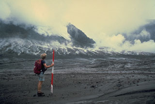
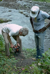
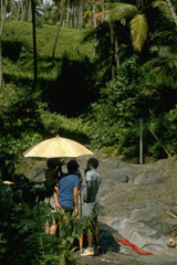 Scientists from the University of West Indies and Smithsonian Institution make precision leveling measurements on the east flank of Soufrière volcano. The optical leveling instrument, under the umbrella for protection from the sun, is used to measure precise differences in elevation between fixed benchmarks. Elevations are read from a stadia rod (across the dry stream bed at the right) placed on top of the benchmark. Areas of stable bedrock flat enough to conduct measurements are difficult to find on heavily vegetated tropical volcanoes.
Photo by Richard Fiske, 1977 (Smithsonian Institution).
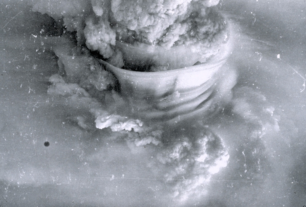
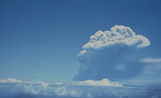
 A powerful eruption column rises above Soufrière volcano on April 17, 1979. The height of the eruption column was estimated to be 19 km. The smooth-textured "skirt clouds" in the center of the photo were produced by condensation of subhorizontal layers of moist air that were carried up by the eruption column.
Photo by Keith Rowley, 1979 (University of West Indies).
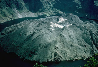
 A growing lava dome rises above the surface of the steaming crater lake of Soufrière volcano in December 1971. The dome first breached the surface of the lake on November 20, after extrusion began sometime in late September or early October. Its height increased at an intial rate of 2-3 m/day before it stopped growing on March 20, 1972. Unlike other historical eruptions of Soufrière St. Vincent volcano, the 1971-72 eruption was non-explosive.
Photo by Jack Frost, 1971.
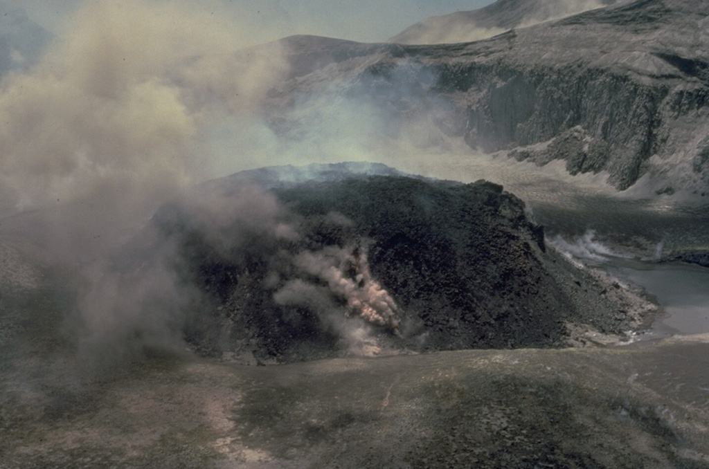
 A steaming lava dome grows on the floor of the crater of Soufrière St. Vincent volcano in 1979. Powerful explosive eruptions that emptied the crater lake and removed the 1971 lava dome took place April 13-25. On May 3 a small lava dome appeared on the dry crater floor. By June 18 it had reached a height of 110 m and a width of 750 m. Diminishing dome growth took place until late October, by which time the dome was 130-m high. This photo was taken from the SW on May 15, during the early stages of dome growth.
Photo by W.H. Hunt, 1979 (Wyle Laboratories, courtesy of National Aeronautical and Space Administration).
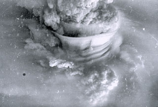
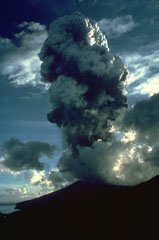 An eruption plume rises above the summit of Soufrière St. Vincent volcano on April 22, 1979. A series of powerful explosive eruptions beginning on April 13 ejected the crater lake and removed the summit lava dome. Pyroclastic flows occurred during several of the explosions and reached the west (lefthand) coast on April 14. Following the cessation of explosive activity on April 25, a lava dome began growing in the new crater on May 3. It eventually reached a height of 130 m and covered 840 m of the crater floor.
Photo by Richard Fiske, 1979 (Smithsonian Institution).
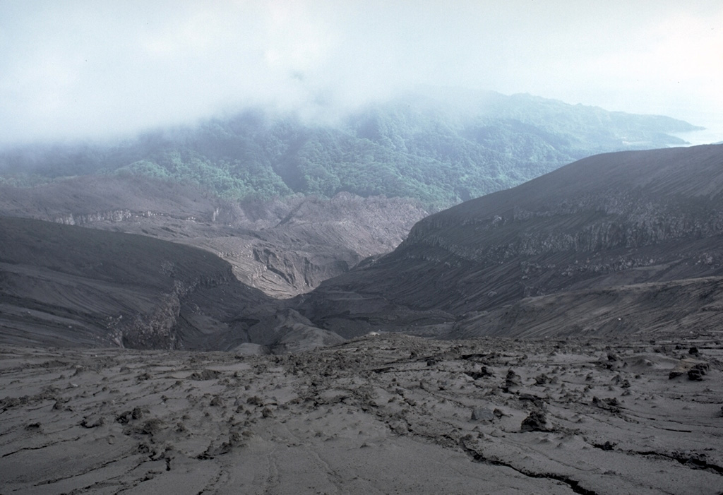
 The barren area in the foreground that extends down valleys to the coast was swept by pyroclastic flows during the 1979 eruption of Soufrière volcano on St. Vincent. This photo was taken on June 1979 from the south crater rim, looking towards the west coast off the island at the right. Explosive eruptions April 13-25 were followed by lava dome growth from May to October.
Photo by Richard Fiske, 1979 (Smithsonian Institution).
 Soufrière volcano, seen here from the south, forms the northern end of the island of St. Vincent. Its broad, flat summit is formed by several generations of craters. The present-day, 1.6-km-wide crater, cut on its NE side by a smaller crater formed in 1812, has been the site of lava dome formation and explosive removal on several occasions since the first historical eruption in 1718. Pyroclastic flows from eruptions in 1812, 1902, and 1979 reached the coast.
Photo by Richard Fiske, 1980 (Smithsonian Institution).
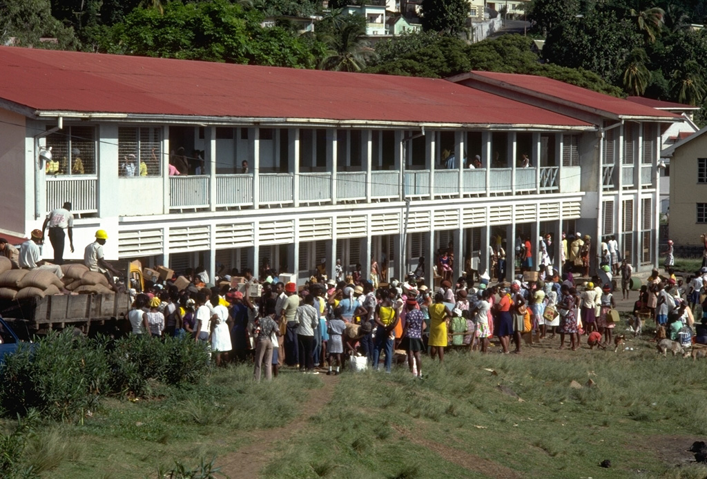
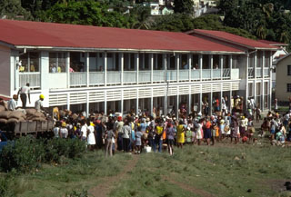 Evacuees from the 1979 eruption of Soufrière volcano pack a school building in Kingston, the capital of St. Vincent. About 15,000 people were evacuated from the northern end of the island. Most were allowed to return home on 14 May, although day-time-only access was permitted for 4000 people living within areas that had been affected by the 1902 eruption.
Photo by Richard Fiske, 1979 (Smithsonian Institution).
 Volcanologist Haraldur Sigurdsson observes a growing lava dome in the summit crater of Soufrière volcano in November 1979 during a field expedition to conduct geodetic surveys of the dome. By the end of the eruption in October 1979 the dome reached a height of 130 m.
Photo by Richard Fiske, 1979 (Smithsonian Institution).
 An eruption column at the right rises above atmospheric clouds on the afternoon of April 13, the first day of the 1979 eruption of Soufrière St. Vincent volcano. The ash column reached a height of 10 km. Several explosions took place on the 13th, two on the 14th, and single explosions occurred on the 17th, 22nd, and 25th. A pyroclastic flow on the 14th descended the west flank and traveled at least 10 km out to sea.
Photo by John Shepherd, 1979 (University of West Indies).
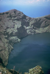 Prior to an eruption in 1971, the summit crater of Soufrière volcano was filled with a crater lake with a maximum depth of 180 m. Its floor was 560 m below the north crater rim. In 1971 a lava dome slowly and almost aseismically began growing on the crater floor. It first breached the surface on November 3 and eventually formed a large island that left only a narrow moat of lake water.
Photo by Jack Frost.
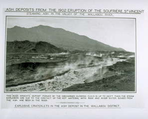 Steaming pyroclastic-flow deposits fill the floor of the Wallibou valley on the SW flank of Soufrière volcano following a powerful eruption on May 7, 1902. Pyroclastic flows reached the coast on all sides of the volcano during one of the largest eruptions in the West Indies in historical time. Pyroclastic flows during this eruption were even more extensive than those that occurred the following day from Mount Pelèe volcano in Martinique, but this eruption is less-well known because of the much greater loss of life at St. Pierre.
From the collection of Maurice and Katia Krafft.
 Volcanologists Richard Fiske and Keith Rowley drill a boulder on the east flank of Soufrière St. Vincent volcano to install benchmarks for deformation surveys. These surveys allow detection of inflation of the volcano that often occurs prior to eruptions.
Photo by John Shepherd, 1989 (University of West Indies).
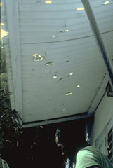 These holes in a wooden awning at the Orange Hill estate, were produced by ballistic ejecta from eruptions of Soufrière volcano. Orange Hill is located at the coast on the east flank of Soufrière St. Vincent, 7 km from the crater.
Photo by Richard Fiske, 1979 (Smithsonian Institution).
 A blocky, andesitic lava dome erupted in 1971 filled much of the floor of the summit crater of Soufrière St. Vincent volcano. This 1977 photo shows the dome, which formed a 70-m-high island in the crater lake prior to its destruction during an explosive eruption in 1979. The 1971 eruption was unusual for Soufrière St. Vincent volcano in that it consisted of slow extrusion of lava that was not preceded by explosive eruptions.
Photo by R. Howard, 1977 (Harvard University).
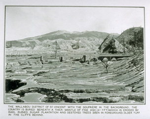 A powerful explosive eruption on 7 May 1902, the day before the much better known eruption of Pelèe on Martinique, devastated the northern part of St. Vincent. This view from the Wallibou valley with the summit of Soufrière volcano to the NE, shows the effect of pyroclastic flows that swept the flanks to the sea. he eruption killed 1565 people and caused extensive damage, including that to the sugar mill in the foreground. Intermittent explosive eruptions continued until March 1903.
From the collection of Maurice and Katia Krafft.
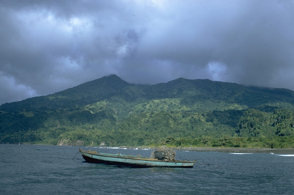
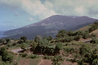
 Soufrière St. Vincent volcano forms the northern end of the island of St. Vincent. The 1178-m-high stratovolcano, seen here from off the west coast, has a broad summit. The peak at the left, the volcano's high point, is the NW rim of a large crater created by a massive volcanic landslide. The present-day, 1.6-km-wide summit crater truncates a cone (forming the flat-topped area across the saddle to the right) that was constructed within the earlier crater. Several powerful explosive eruptions have occurred in historical time since 1718.
 Photo by William Melson, 1972 (Smithsonian Institution).
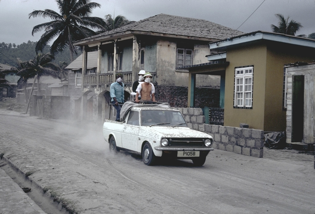
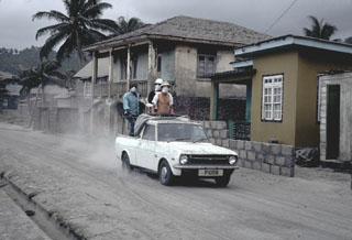 A truck filled with people evacuating the eruption of Soufrière volcano drives through the streets of the city of Georgetown, SE of the volcano, in April 1979. The riders are wearing masks because of ashfall. About 15,000 people were initially evacuated from the northern half of the island, which had been devastated by a previous eruption in 1902.
Photo by Richard Fiske, 1979 (Smithsonian Institution).
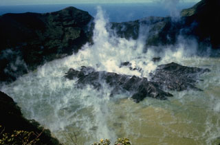
 Steam rises from the margins of a growing lava dome in the summit crater of Soufrière volcano on May 7, 1979. This photo was taken from the SW crater rim 4 days after the beginning of dome growth. By June 18 the dome had reached a height of 110 m and was 750 m wide, covering much of the crater floor.
Copyrighted photo by Katia and Maurice Krafft, 1979.
This is a compilation of Saint Vincent and the Grenadines volcano information sources, such as official monitoring or other government agencies.
| Volcanic Ash Advisory Center | |
|---|---|
| Washington Volcanic Ash Advisory Center (VAAC) | |
| - Washington VAAC Archive | |
| - Washington VAAC Notices | |